Friday, November 19, 2010

Nov. 9-15, 2010 (Week 6, Day 36-42)

Tues. Nov. 9, 2010 (Week 6, Day 36): Destination: Tom Point Creek (Mile 495.7) to Beaufort, S.C. (Mile 539.6) Departure: 0650 hrs. Arrival: 1330 hrs. Mileage: 43.9 SM Weather: a burning red sky hung over the salt marsh grasses as the sun was trying to poke it’s head over the horizon, then brilliant sun in a cloudless, blue sky; tempà cool, probably mid 40’sF but a warming trend approaching with highs in the mid 70’sF Winds: WNW at 3-5K

Larry had to cut the wire to his newly installed bilge pump as it started running & would not shut down + the fridge was not functioning! This is not good! Thus our 0630 hrs. departure was delayed till 0650 hrs. & now a marina was a necessity for them. As for us, that decision was delayed as we had planned to anchor in Factory Creek & dinghy to the city docks to be able to see Beaufort (a definite must see on my list). Anchor came up clean as a whistle again. Rising tide from the North Edisto River into the Dawho River at Mile 496.7 at White Point; wound our way as per chartplotter. We had a few caution shallow water areas today & a rising tide was necessary; (1) Fenwick Cut--> good, (2) Ashepoo Coosaw Cutoff #1-->20+ ft. deep at near high tide, (3) Asepoo Coosaw Cutoff #2--> min. 14 ft. (hardly recognized the cut with all this water !), (4) Brickyard Creek--> high tide; we were keeping pace with rising/high tide. Lady Island Bridge (swing) is on an irregular opening schedule because of the construction on the fixed bridge (J.E. McTeer Bridge) by Port Royal Landing Marina (Aug. 2011); plenty of time for the 1300 hrs. opening. A 2-3K current pushed us to Port Royal Landing Marina; we decided to do 1 night with the Morrows then anchor out. We were assisted by dock staff & tied up without incident to the face dock; lots of construction noise. We had Morrows over for supper (coq au vin, potatoes & broccoli)--- much appreciated especially with their mechanical problems; Morrows brought over carrot cake for dessert! The construction noise continued all evening till 0300 hrs. then resumed at 0530 hrs. Internet--> problems with posting of my blog & sending an email of the post to my category (a brain wave Wed. night & problem corrected). A clear night, stars & warm enough all night without heater.

ICW Waters: Dawho River-->North Creek & Watts Cut-->South Edisto River-->Fenwick Cut-->Ashepoo River-->Ashepoo Coosaw Cutoff #1-->Rock Creek-->Ashepoo Coosaw Cutoff #2-->Coosaw River-->Brickyard Creek-->Beaufort River

Interesting Info: Numerous sea islands rivers & creeks along the South Carolina coast ie Coosaw Island, Morgan Island, Ladies Island, St. Helena Island, Tripp Island, Parris Island, Hilton Head Island, Pinckney Island, Dafuskie Island.

Wed. Nov. 10, 2010 (Week 6, Day 37): Destination: to stay in Beaufort (Mile 539.6 & to stay at marina (pay 2 nights, get 3rd free) + want to see Beaufort more extensively to get a real feel for the community Weather: sunny, blue skies, no clouds, high= low 70’s, low= low 40’s Wind: nothing to speak of

Woke up early because of the construction. I met a seasonal nurse (works 6 mons., cruises 6 mons.) who works at the Beaufort Memorial Hospital while showering up in the marina. After breakfast Graeme added diesel to the boat tank, I did some housekeeping chores in the shower room & head. We signed up for the courtesy car & the 4 of us tootled off to West Marine, Piggly Wiggly, a canvass shop by Lady Island Swing Bridge then over the bridge, parked the vehicle then walked in & out of shops on Bay St.; back to the car then drove around historic streets, especially NE of Carteret St. Once back to the marina we had a few beers & snacks from the grill restaurant on the premises; who wants supper now? We did have a very late light supper (soup) & read + internet--- ironed out my difficulties. Graeme went to bed before me again! Clear sky filled with stars & crescent moon. No large construction noise tonight, only powerful light (not a problem); probably pouring cement.

Thurs. Nov. 11, 2010 (Week 6, Day 38): Remembrance Day/Veterans Day. Unfortunately we don’t have poppies to wear. Destination: Beaufort (Mile 539.6) Weather: sunny, warm with high in mid 70’sF, blue skies Wind: light with a few gusts

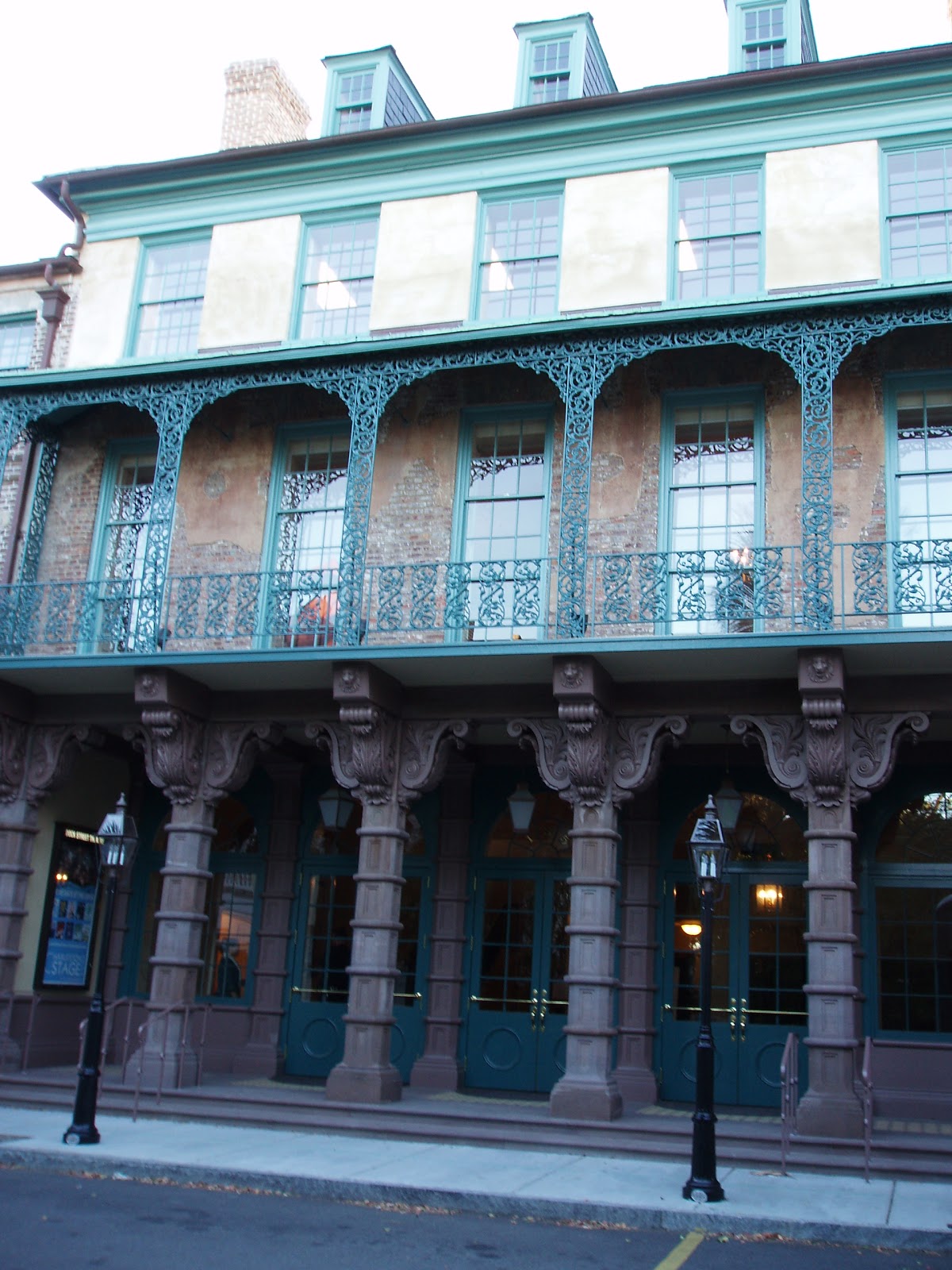
Slept in--- 0700 hrs.! Breakfast, shower at the marina, assembled bike & organized myself for sightseeing historic sites. Lynn was doing laundry while Larry did some V-berth maintenance while awaiting some packages that were arriving via UPS; Graeme--> ?. We will meet for lunch at 1230 hrs. at Luther’s (used to be a pharmacy). I left the marina by bike at 1045 hrs. & stopped several times to look at & take photos of historic sites according to my guide. Lunch at Luther’s was great then more sightseeing while the others drove back. The park at waterside is beautiful--- brick sidewalks amongst the many garden beds, many eateries with patios facing Beaufort River, swinging benches at river’s edge. My bottom is no longer used to sitting on a bike seat. Home at 1600 hrs. & as we were packing up my bike a few no-see ums made their annoying presence. Over to the Morrows for homemade thin crust pizza--- yummy! Larry had his T.V. hooked up but the Sens vs Vancouver game was not televised for our viewing. An early night. Dew everywhere; clear skies, ¼ moon & stars. I do not regret the extra time in Beaufort; I now have a good feel for this beautiful, romantic, friendly community.

Fri. Nov. 12, 2010 (Week 6, Day 39): Destination: Beaufort, S.C. (Mile 539.6) to Bull Creek off Cooper River (Mile 565.5) Departure: 0810 hrs. Arrival: 1215 hrs. Mileage: 25.9SM Weather: sunny, cool (high 60F, low 45F), no clouds, only blue skies Winds: calm of last 3 days replaced by cool & brisk NNE winds at 13-15K

Plans altered slightly from leaving at 0730 hrs. until staff arrived at 0800 hrs. to assist with departure secondary to strong winds, chop, opposing current & bridge construction directly behind; still at low water slack; good departure. “Twomorrows” after clearing the fixed bridge under construction had to quickly swerve & slow down to avoid a construction barge. We motored from Beaufort River into the Port Royal Sound passing Parris Island on our starboard side against the current & the wind was NNE on our port quarter until R246; unfurled some jenny then jibbed with a wide sweeping turn around R246 on a beam reach on port tack & the current now with us; speed= 7-8K. At 1010 hrs. we turned into Skull Creek which separates Pinckney Island from Hilton Head Island. ‘Twomorows’ anchored off Skull Creek Marina hoping to have fridge repairs done today, while we continued on past several marinas, under the Wilton J. Graves Bridge (fixed & the only auto access to & from Hilton Head) into Calibogue Sound; flood tide therefore we were going against the current until we turned into the Cooper River; now the current is with us. Daufuskie Island was on port; author Pat Conroy in his book “The River is Wide” wrote about his life as a schoolteacher there. At Mile 565.5 we turned off the ICW into Bull Creek & anchored in 15-18 ft. with rising tide till 1402 hrs. (80 ft. chain). It was early to stop but we did not want to put too much distance between us & Lynn & Larry. Also we wanted to stage for Fields Cut & the Savannah River. As I sat in the cockpit eating lunch & doing some prep reading with the sun beating down, I was starring at the live oaks, palmetto palms, pines, shrubs & 2 maybe 3 homes on one side & salt marsh grasses on the other side; I watched the ICW traffic---all so very peaceful, a contrast to marina life. Late in the afternoon we received not good news from the Morrows--> wrong part shipped! They will call in the am. Supper= leftovers for me (thai coconut chicken with added shrimp) & sweet & sour meatballs for G. Journal writing, some reading & eyes slammed shut at 2100 hrs. A very peaceful night, clear sky stars+++, 2/3 moon; total 5 boats anchored here overnight. This was our last day & night in South Carolina.

ICW Waters: Beaufort River-->Port Royal Sound-->Skull Creek, Hilton Head-->Calibogue Sound-->Cooper River

Interesting Info re Hilton Head: Explored by English Naval Captain William Hilton in 1663. Once the danger of Indian attacks decreased, families settled & built plantations, which now have vanished but are remembered in the name of resorts. The land was farmed for Sea Island cotton, sugar & indigo. Home of 2 civil war forts & Baynard Ruins, a prosperous plantation. In the 1950’s the Sea Pines Co. was the first to begin resort development. Today Hilton Head has the largest collection of condos, hotels & restaurants & marinas in coastal S.C. The island is boot shaped, 42 square miles with 12 miles of ocean beach. Incorporated as a town of about 30,000. Acres of untouched forest & marshland. Nature paths, catwalks, regular scheduled bird walks, museum & sponsored beach walks, extensive bike paths. Gullah is the low country’s population of direct slave descendants & their unique language, eating, art & tradition--> museums & feastivities.

Sat. Nov 13, 2010 (Week 6, Day 40): Destination Bull Creek (Mile 565.5)to Savannah—Turner Creek (Mile 585.5) Departure: 0935 hrs. Arrival 1315 hrs. Mileage: 20.0 SM Winds: calm, N

We awoke 0630 hrs. but stayed in bed while the other boats departed; still low tide or slack low till 0730 hrs. We wanted a rising tide at least; best would be a mid rising tide. We were also awaiting word from the Morrows; called at 0900 hrs. & no news from the repairman so he was unable to jerry rig anything; will check back at 1700 hrs. We moved on taking advantage of flood tides. Sometimes we were moving with the current & sometimes against, depending on our position passing the multitude of streams behind a chain of barrier islands on their Atlantic coastline. Passage past Daufuskie Landing, extensive shoaling area in vicinity of Ramshorn Creek, entrance into Wright River, the north & south ends of Fields Cut (11-20 ft.), the crossing of the Savannah River (strong currents & possible big ships) & confluence of Elba Island Cut with the Savannah River all went well--- good planning. We are now in the state of Georgia. There was no waiting for the opening of the Causton Bluff Bridge, also called Sam Vernadoe Bridge (bascule)--> 3 boats passed. We slowly passed through Thunderbolt & turned off the ICW at R40 & continued to Turner Creek, following the semicircular path of the creek nearly to it’s end to Hogan’s Marina. We had no knowledge or information for this area so committed to one night at the marina--> electricity, no WiFi, two toilets & one shower simple, clean but inside office building, so when office closes at 1700 hrs. no facilities, but they open at 0700 hrs. (Dec. 0800 hrs. opening). There is an anchoring field just very slightly north of us with an easy dinghy ride to this marina. Dinghy tie up= $10.00 per day. After lunch we walked to the library & worked on emails till 1615 hrs. Graeme walked back earlier looking for the hardware store & purchase some beer at the Publix right next door. On my way home I checked out the bus stops & tried to locate a bus schedule for our tour of historic Savannah tomorrow & picked up some milk, oh maybe a few other things, as I browsed the aisles seeing what was on special at Publix. I will pick up salad & bread stuff before we leave this location. Marina faces west; the sunset was wonderful. Supper= fresh corn on the cob, then pork chop & potatoes for G & leftover coq au vin with added shrimp for me. Graeme extremely tired & in bed early. Journal writing+++. Heater is on just to keep the chill at bay, but night sky clear, near ½ moon, stars & cool (heater); water flat calm.

ICW Waters: Cooper River-->Wells Cut-->Wright River-->Savannah River-->Elba Island Cut-->Wilmington River.

N.B. Library hours: Mon. & Tues.--> 1000-2000 hrs. Wed. & Thurs.--> 1000-1800 hrs. Fri. & Sat.--> 1400-1800 hrs. Sun. closed

Publix hours: 0700 hrs.-2300 hrs. everyday

Interesting Info: The geography of S.C. & Georgia coastlines are similar; mostly deep with many streams behind a chain of mostly uninhabited barrier islands. The waters are very tidal with swift currents & tidal ranges sometimes > than 8 ft. The rapid water movement is more pronounced in Georgia & tends to keep the bottom of even small creeks scoured & deep with a few exceptions. Very limited dredging in this state & increasing shoaling.

Sun. Nov. 14, 2010 (Week 6, Day 41): Destination: Savannah (Turner Creek—Mile 585.5) but anchored out in the creek Weather: wall to wall sun, blue sky, no clouds, verging to very warm temps Wind: nil Tide: low= 0830 ish high= 1500 ish

Out of bed at 0645 hrs., breakfast, shower & attended the Lutheran Church across the street for their 0830 hrs. service--> very similar to R.C. Mass. Meanwhile Graeme walked to the library, sat outside & accessed internet for the few emails he needed to attend to but with at lot of frustration apparently. No buses from here, Wilmington Island on Sundays! There went those sightseeing plans for today. Then tomorrow it will be. I was able to copy the #24 bus time schedule from the marina’s office only copy (is it up to date?). We untied from the dock at 1100 hrs. & anchored in the creek; Graeme readied the dinghy & motor. Gentleman on Bristol (Tanzar) slowed his dinghy & spoke to us; he & his wife are from Belleville, Ont. He had some interesting info--- $15.00 Savannah tour 1-1/2 hrs., excellent & very well worth it; iPAD with 3G pays $29.00 per month & almost constant internet & weather with radar application; highly recommends calling Patrol & Border Crossing at each port. After lunch we tied up the dinghy at Hogan’s Marina--> no charge today because of overnight stay. We walked to ACE Hardware (large) & Family Dollar then back home about 1530 hrs. While we sat in the cockpit I was reminded for some time now, at least since Georgetown, S.C., the sound of birds’ call similar to the bird sounds of the Caribbean --- blissful. A striking sunset. Supper= corn on the cob, cube steak, onions & potatoes. Night sky clear, ½ moon, stars, calm & not as cool as last night. Graeme has read through 4 books, I nil. Early bed tonight so as to get the early bus into downtown Savannah tomorrow.

Mon. Nov. 15, 2010 (Week 6, Day 42): Destination: Savannah anchored in Turner Creek Weather: dew+++, slightly coolish temp. about 60’sF, full sun Winds: light, not enough wind to get wind gen to work

Our boat direction changed with the tides; not really affected by wind, especially today with so little winds. A boat shower, breakfast & by 0730 hrs. we were in the dinghy so as to tie it up at Hogan’s Marina ($10.00 per day). We walked to the #24 bus stop in front of the BP station--- arrived at 0815 hrs.; we met Barb & Jim from New Bern, N.C. (trawler) also going to downtown Savannah. The bus ride was about 45 min. dropping us at the corner of Martin Luther King Jr. & Broughton, 2 blocks from the Visitor Center. We paid for an Oglethorpe Trolley Tour--- 90 min. long at $15.00 per person with unlimited on & off bus privileges till 1730 hrs.; throughout the historic area. Mickey was the name of our tour guide--> very good; highly recommend tour for 1st time visitors. The tour ended at The Market (0930-1100 hrs.) We walked The Market (2 blocks) had an early lunch at ‘Tapis’ & planned our walking route. We walked the length of River Street with it’s many shops, Factor Row & Factor Walk taking lots of photos; now 1400 hrs. Then we walked some of the historic streets, squares & houses pointed out to us on tour; again more photos. To ‘Leopolds’ infamous for their ice cream especially their Tutti Fruiti flavor; will be moving back to their original site on the corner of Gwinnett & Broughton in the Spring. We only covered 1/3 of the historic area by foot as we made our way back to our bus stop, stopping for a beer, thinking we had time to spare. But I had read the schedule wrong, missed the 1555 hrs. bus & now had to wait an hour & get the last bus. The return ride was in the dark busy with working folk getting off of work, & it took approximately an hour before our stop. We made a detour to the Publix before going to the dinghy. The Morrows called; rented a car & toured & shopped in around Hilton Head. Supper= hot dog + a cob of corn for me. A cloud cover rolled in late afternoon & rain predicted for tomorrow. Do we go on to Redbird Creek tomorrow or stay here tomorrow? We will see what we feel like doing in the am. A warmer night.

Interesting Info: This will be added in the near future!

Wednesday, November 10, 2010

Nov. 2-8, 2010 (Week 5, Day 29-35)

Tues. Nov. 2, 2010 (Week 5, Day 29): All Souls’ Day 
Destination: Still Georgetown (Mile 403)                                                                                                 Weather: cool & cloudy, very few small blue patches spotted in sky                                                    Winds: gusting 8-15K North winds; cool especially when wind blowing

Breakfast at Thomas Café at 0900 hrs. with the Morrows--> good & ample. Chatted away till 1100 hrs. Back to the boat & I changed into warmer clothes, then Graeme dinghied me back to shore--> self directed walking tour of the downtown historic houses dating 1737 to 1901, 1902, 1903 to 1908. Graeme did odd jobs + ?. He & Larry were going to help each other go up each other masts but too cool & windy. Graeme picked me up at 1430 hrs. then we changed out location due to change to north winds & more availability of space closer to Harborwalk. Lynn & Larry dinghied over about 1530 hrs., then Larry & I dinghied to Independent Seafood & each bought 1-1/2 lbs.medium large shrimps (head off -->$ 5.99/ lbs., head on--> $2.99/ lbs.). Supper= thai coconut chicken & rice; Graeme’s opinion was good for chicken well I found it scrumptious. Journal/blog writing then turned in early. Skies remained cloudy & winds still gusting from the north.


I guess this is a good time (beginning of our 5th week) to add comments re personal interaction--- just as difficult as the first time. It is a male/female thing I guess--- women are from Venus & men are from Mars. It is difficult when a multi tasker is trying to work with someone who operates only one job at a time; a constant priority setter vs what’s a priority? It is very helpful to socialize with other cruisers who also are experiencing the same difficulties--- comforting if nothing else. I can’t speak for Graeme as he is Graeme & does not talk of his emotions, thoughts, feelings. I feel internal tension & know that I am not always in control & show this emotion through action, words & body language. I left anxious to get going while we were still in Deltaville & yet I had anxiety as to what was about to occur, what may happen. Two years ago it was anxiety of innocence & not knowing what to expect. But now it is almost anxiety of too much knowledge & the struggle with my internal desire for adventure. There is a struggle between Graeme’s over protectiveness & almost pessimistic attitude & my more carefree approach. I have had my melancholy moments thinking about 2 years ago & how worried I was about my parents. I still think of Dad; I think of the last hours we had together so vividly. My eyes well up in tears.


Wed. Nov. 3, 2010 (Week 5, Day 30):                                                                                              Destination: Georgetown (Mile 403) to Awendaw Creek (Mile 435.7)                                                    Departure: 1015 hrs.                         Arrival: 1450 hrs.                                      Mileage: 32.7 SM                                                                      Weather: grey & cloudy                                                                                                                                     Wind: light & North with occasional gust that got the wind generator whirling.

Garbage was taken to shore; motor was taken off the dinghy & placed securely on the stern rail & the dinghy tow lines were set for towing. The anchor was up at 1015 hrs. & it was nothing but a motorboat ride. Low tide was near it’s completion so we had the current pushing us down the Winyah Bay to the Estherville Minim Creek Canal at Mile 410.5 (an abrupt turn to starboard). The ferry at Mile 411.5 was not crossing & we saw no eagles. Similarily around Mile 425, the Cape Romain National Wildlife Refuge, there were no alligators seen & very few birds except cormorants. And no one was interested in stopping at McClellanville Mile 430 (depths= 9-11 ft.)--> an inside joke. At Mile 435.7 we left the ICW at R48 & motored into Awendaw Creek, with surprising good depths at the entrance of about 9 ft. Three other boats at this anchorage that comprises of 3 sides of salt marshes & one wide mouth that flows into the Bull River that opens directly into the Atlantic. I boiled up the fresh shrimp purchased yesterday afternoon, shelled & froze 2/3, leaving some for supper tonight & for lunch tomorrow in my salad. We tried to row over to ‘Twomorrows’, but the current was too strong so dissembled the engine off the stern & assembled it on the dinghy. A couple of hours of socializing over a couple of drinks. Supper = leftovers to which I added the fresh shrimp to my dinner--- even more scrumptious. The north wind laid down to next to nil & the boat turned 180 degrees from when the anchor was set --> current flooding. Rain & thunderstorm predicted to start near midnight & all of tomorrow. We will finalize our plans in the morning & adjust according to the weather.

Thurs. Nov. 4, 2010 (Week 5, Day 31):                                                                                                  Destination: Awendaw (Mile 435.7) to Whiteside Creek (Mile 451.5)                                                    Departure: 1250 hrs.                       Arrival: 1545 hrs.                                    Mileage: 25.8 SM Weather: fogà solid grey cloudsà fog à rain with some lightning & thunder; heavy rain just after we pulled up anchor.                                                                                                                                         Wind: W & WNW; seemed light in am, about 7-8K down the ICW, & 8-10K upon anchoring & on


It was questionable whether we would move on today because of the fog in the am & weather. ‘Twomorrows’ & ourselves stayed in contact with each other on VHF 16à17 on an hourly basis starting at 1000 hrs. Lynn’s blackberry & internet capabilities kept us abreast of the weather & improving situation till this evening. Lots of traffic conversation on the ICW over the VHF. Another delay at 1100 hrs. so took that opportunity & buzzed Graeme’s hair off, then lunch. At noon we decided to up anchor at 1230 hrs. By this time the tide was low & nearing completion of that cycle, so lots of skinny water seen on our depth sounder. It is kind of alarming when you see depths of 3.9, 3.2 after some of these trawlers pass; they have churned up the channel waters so much to give these false readings. Also the number & size of trawlers & the wake that they create play huge havec on the shores of the waterway. Caution areas to be on a look out at low tide were from R60 to R64 & R84 & 86. I almost forgot, even without a fishing rod we were catching fish--- a 12 inch fish (? bass) had leaped into our dinghy & was frantically flip flopping on the bottom of the dinghy; poor thing! Animal life was more active today; no alligators but we did see a bald eagle perched on a piling & the graceful swimming dolphins were back in good numbers especially approaching R94 & at the mouth of Whiteside Creek. We turned to starboard just north of R96 & anchored in 13 to 18 ft. of water; hard to tell because of the influence of wind & a stronger current that was 90 degrees off the wind. High tide would be around 1900 hrs. & hopefully the anchor chain will stretch out. I tried to rescue the fish in the dinghy but it was too late; rigor mortis had set in, but it’s eyes were clear. I picked him up & Graeme took a photo of the fish & I, then I launched him into the South Carolina waters. I wonder what he would have tasted like? Lynn & Larry saw a mother & baby dolphin (small) at their stern. Well Graeme read & kept checking our anchor, I did some serious reading re Charleston. We had supper at a reasonable hour of 1800 hrs. tonight= sweet & sour pork chops. Night has arrived, the wind is howling & so is the wind generator. A Skipper’s Meeting earlier decided that we would be on the go at 0830 hrs. hoping to get into our slips in Charleston early.

Fri. Nov. 5, 2010 (Week 5, Day 32):                                                                                                     Destination: Whiteside Creek (Mile 451.5) to CharlestonàMaritime Center (Mile 464.1)                   Departure: 0835 hrs.                           Arrival: 1115 hrs.                                 Mileage: 12.6 SM                                                                               Weather: cool (48F) but awesome sunrise to crystal clear blue sky; high temp= 60F                                                      Winds: West at 8K

High tide when the sun rose so the sunshine on the salt marsh grasses casted a golden colour all around. These grasses were nearly totally submerged this am, where last evening even their roots were exposed. Anchor up & totally clean as a whistle. The slips at Charleston Maritime Center were vacant & free for us to arrive any time. The flocks of pelicans were amazing this am; they were following a small fishing boat pulling up crabpots. 1015 hrs. the Ben Sawyer Bascule Bridge opened for our passage & at 1025 hrs. we were in the   
Charleston Harbour at first with the current with us (speed= 7.5K) but shortly against us (speed 3.9K). By Charleston Inlet we spotted a few fishing trawlers, a sailboat & a speck that probably would be a freighter way in the distance; must keep an eye on him. View of Charleston was spectacular---The Battery, the many church steeples (the highest points in the city), Ravenel Bridge, & Patriots Point (Yorkton). Two tugs were awaiting the arrival of the freighter which soon was on our tail. The marina gave us our entry instructions--- the current & wind against us (favourable in this instance). BUT we were not aware of & did not make provisions for the current entering the marina; we were being sucked into the bow sprint of the schooner tied up on the wall outside the entrance. Graeme pushed the ass end of the boat enough so only the blades of the wind gen. clipped the bow sprint--- holy hanna! New moon today so the tides were more than usual (7 ft. tide difference). A quick lunch after tied up, gathered up the laundry but 3 other people in line for use of 1 free washer & 1 free dryer (0800-1800 hrs.). I walked a couple of miles to Broad Street Barber Shop; no lineup, hair cut & done by 1330 hrs. (not a great cut but, get used to it; this is only the 1st of many poor cuts I will have). I walked up Broad to check out church times for Sunday, first at the cathedral then at the Episcopal church, through ‘The Market’, picked up a few groceries at Harris Teeter (open 24 hrs.)& veggies at the ‘Vegetable Bin’ & was back just in time to start my turn at the laundry machines; finished 2nd load at 1800 hrs. This afternoon Graeme & Larry hauled our anchor out on the dock & wrapped tie-wraps along it’s length every 20 ft. Skyped Mom since the family has not heard from us since last Sat. 62 emails waiting! A shower followed by a scrumptious spaghetti dinner at the Morrow’s. Quite cool temp & cool wind blowing tonight but clear, star filled sky & we were toasty warm with our electric heater.


Sat. Nov. 6, 2010 (Week 5, Day 33):                                                                                                             Destination: to stay in Charleston (Mile 464.1)                                                                                            Weather: breathtaking sunrise, mist over the water that looked like little patches of snow hovering just over the surface of the water; cool & a very cool wind                                                                             Winds: ENE about 10-15K; because of the direction of the wind during the night there was a lot of boat movement & slapping of water against the hull so sleep was interrupted.


I was at the laundry facilities by 0800 hrs. & did my final free load of laundry. I assembled my folding bike but walked to the Rite Aid Pharmacy & Farmers Market (every Sat. at the corner of Calhoun & Meeting). Graeme & Larry went up both their masts to observe steaming light in our case & repositioned the anemometer & wind indicator in Larry’s. After lunch Graeme & I walked to ‘The Market’ area & browsed, met Lynn & Larry & had snacks & drinks at Tom Condon & walked home. More drinks & snacks at the Morrow’s; afterwards who wanted supper--- chicken noodle soup & grilled cheese sandwich. Telephoned Mom, then internet. Tonight was quite cold, strong NE winds, clear skies filled with stars. We were very cozy again tonight with the heater. Switched to standard time tonight!


 Interesting history re Charleston: Charleston is also called the “Holy City” because of the many steeples in it’s skyline. It is a religious community whose roots from colonial era has shown religious tolerance--- 1680 the French Huguenots fled their homeland because of religious persecution & later the Dutch & German immigrants, but the French influence was the strongest. Charleston is not just a city, but a way of life where local citizens live & work in the historic homes & buildings. The social history has been divided by some authors into two eras: (1) “Open City” when Charleston acted as a sponge soaking up education, culture & science from all over the world; (2) “Closed City” when large sums of money were concentrated in the hands of wealthy, slave-owing planters. The lower class were there to toil & the aristocracy was there to reap the benefits. It was no longer opened to the outside world. This period produced much that was glamorous & romantic; many tales & beautiful homes had their roots in the planter society. In 1663 all of the land now North & South Carolina was given to 8 lords/friends of King Charles II. In 1669 3 ships set sail from England to found a new colony making landfall at Port Royal Sound but moved north & founded Charles Town on Town Creek on the Ashley River. It suffered many major fires, several hurricanes & an earthquake as well as wars against the British (1780-82) & the Civil War. Hardship years followed until WWII . In the 1950’s & 60’s there were renovation projects that has preserved Charleston’s historic character & they continue today.


Sun. Nov. 7, 2010 (Week 5, Day 34):                                                                                                               Destination: to stay in Magnificent Charleston (Mile 464.1)                                                                                    Weather: due to the time change more day light than when on daylight saving for the same time; sunny+++, blue skies                                                                                                                                         Wind: cold North winds 15K, whitecaps on Charleston Bay

I cycled to the Cathedral of St. John the Apostle for 0800 hrs.--- an extremely traditional mass with even some Latin songs. Mass hours: Sat. 1715 hrs. Sun. 0800, 1115, & 1715 hrs. Then I cycled up to The Battery & in & around all the historic streets & sites of old Charleston. The streets had all been washed down from the horse manure from the many carriage tours. The city was very slowly waking & coming to life. Charleston is so magical. A little housekeeping & fridge maintenance. Larry’s brother & sister-in-law from Augusta, Georgia arrived & they went off to the big store shopping. We drained & refilled our water tanks (45 gal. X 2) & fuel tank in preparation for departure tomorrow. Last bit of grocery shopping at Harris Teeter & packed all the supplies in their appropriate spots on the boat. More walking in the historic district & met the rest of the gang for dinner at the ‘Noisy Oyster’; wonderful food & exceptional waitress. The evening was cool but the wind had died down, a beautiful night for walking, but Rick insisted on making 2 trips to drive all home. I phoned Mom as she leaves tomorrow afternoon for her 3 week vacation to New Zealand & Australia, a lifelong dream come true! Internet, blog posting of Week 3 & 4. We worked out the tides departure time in order to hit the bascule bridge for it’s opening & the passage through Elliott’s Cut with the current---no repeats of last time. Again a beautiful, star filled night sky but very comfy warm with the heater. Bedtime at 2300 hrs.

Mon. Nov. 8, 2010 (Week 5, Day 35): Mom, have the time of your life!!!                                                  Destination: Charleston (Mile 464.1) to Tom Point Creek (Mile 495.7)                                                                Departure: 0735 hrs.                                  Arrival: 1250 hrs.                                   Mileage: 31.6 SM                                                                                    Weather: pleasantly & moderately cool temps & brilliant sunshine, no clouds                                                  Winds: light from the West averaging 6K but variable, Charleston Bay calm

Up at the crack of dawn & dock lines untied & exited port without any issues; all my worrying for nothing. We had a high tide pushing us down the Ashley River towards the bascule bridge so speed & time management important; 14 boats awaiting the Wappoo Creek Bridge (restricted) opening at 0900 hrs.--- circling, forwards & backwards & jocking around. Then single file we flew through Elliott Cut with the current at 8.2K ; I hardly recognized the cut--- high water level right up to the shoreline compared to the rock shoreline at low tide during our passage in 2008. The line of southbound sailboats in time split into 3 groups from fastest to slowest. We motored along with the current at 6-7K down the Stono River with the wind on our nose to the Wadmalaw River (marsh flats covered at high tide). At Mile 480 R40 the current reversed & fought it with at speed now of 4.8K. Mile 495 brought us into the North Edisto River & at R102 we turned to starboard into Tom Point Creek; anchored about a mile into the creek in 18 ft. with 80 ft. of chain; I can tell the exact amount now! Still warm, sunny, blue skies & winds still from the west at 8-9K, enough to keep the wind gen. working. Near low tide water depth= 13 ft. At maximum low tide it felt as if we were in a ditch; mud banks totally exposed & salt marsh grasses higher than our sitting level on the boat. I read from 4 resource books about the upcoming passages & particularly about Beaufort, S.C. At 1730 hrs. the tide & current started to change & slowly the bow of the boat changed from a southwest direction to northeast; wind nil & water flat calm. Skippers’ (Admirals’) Meeting held on ‘Sweet Chariot Too’; in order to pass the Ashepoo Coosaw Cutoff (about 20 miles away)at high tide we need to up anchor at 0630 hrs. There should be daylight by then but the sun will not have risen yet. Supper= hamburgers + extra future meals made with the rest of the ground beef. Clear dark skies with millions of stars. I still have not studied the constellations.

Saturday, November 6, 2010

Oct. 26 - Nov. 1, 2010 (Week 4, Day 22-28)

Tues. Oct. 26, 2010 (Week 4, Day 22): Our Anniversary! 
 Destination: to stay in Beaufort 
 Weather: increasing S winds, rain & thunderstorms predicted; but in the early am the skies were clearing to a brilliant blue sky & sun with nasty clouds to the W; winds were gusty & moderately strong.
We signed up for the courtesy car after a shower & breakfast (0930-1145 hrs.). We drove over to Atlantic Beach, walked the public sand beach (empty, & ocean rough) until the stores opened at 1000hrs. Brigitte from Town Creek Marina recommended a surf shop (Marsh’s on the right at the base of the bridge) who carry Maui Jim sunglasses; they were closed when we past & saw another (Bert’s)àpurchased. Then we walked the Morehead City waterfront where we have been in ’09---many shops have closed up. Then it was back to Beaufort to Front St. (main tourist area right next to the waterfront of Taylor’s Creek); we visited a few shops then it was time to return the car. At lunchtime it was still sunny & hot (75 F)now; skies were still blue & the winds were still moderately high. We phoned the US Coast Guard (USCG) to confirm rumoured delays &/or closure of the passage by Camp Lajuene & anchorage at Mile Hammock---no known delays or closures. We worked away at the internet & got the first two postings of my blog out to those who specifically approached me that they wanted to receive it. The courtesy car was available again in the late afternoon so we made at trip to West Marine out Hwy. 70W in Morehead City, then to Atlantic Beach again for a pair of sandals I was looking for. We opened a superb bottle of red wine & enjoyed it before & with our steak dinner. I worked on the internet while Graeme have a few zizz hours. Although the weather predicted did not materialize but seemed to stay west of us, we enjoyed the stay anyway. Tonight a ¾ moon was visible in a hazy night sky.
Wed. Oct. 27, 2010 (Week 4, Day 23): 
Destination: Beaufort(Mile 205) to Mile Hammock (Mile 244.5) 
Mileage: 39.5 SM 
Weather: Partly sunny & partly cloudy dawn with S to SW winds moderately strong & gusting 9-18K.
Departure: 0740 hrs. 
Arrival: 1445 hrs. 
A fellow cruiser helped with our dock lines, pile lines good, but a very messy exit! We mingled below Beaufort Bridge (bascule) awaiting the 0800 hrs. scheduled opening; restricted openings for the am & pm traffic on weekdays. There was a whole string of power & sailboats southbound in the Bogue Sound passing all the fine large expensive homes on the Morehead City side & the beach communities on Bogue Banks. We motor sailed with some jenny (a beat) at 7-8K until we turned into the wind at about Cedar Point then Swansboro; we went aground with sail up between G15-17 by being too close to the green side when one really needs to favour red sideà easy off. The sun was in & out but mostly out, warming temperatures to a hot 80 F. Dolphins+++ playing with all of us near Mile 230, Bear Inlet. As per routine, I spend many am hours reading about today’s passing communities & their histories, caution areas (low water/shoaling) spot cleaning the main cabin floor & the cockpit & spelling Graeme off the wheel , some days more than others. He usually charts stuff, cleans as well & thinks silently when not driving. We got the 1400 hrs. Onslow Beach Bridge opening, then onto Mile Hammock---several boats anchored already. The anchor was set with lots of chain out in 13 ft.of water deep down towards a ramp & we set the wind gen to ‘on’---it’s whirling it’s guts out. There was a little chop, gusting winds from the south at 10-15K., the clouds rolled in & the skies were threatening. Not very favourable weather conditions predicted for overnight & all of tomorrow. Despite washing the entire deck & dodger & bimini windows a couple of days ago, the salt air was very evident. A few more boats entered the anchorage well after sunset. A well light up tug pushing a flatbed freighter passed & in the distance we could see the lights of Surf City. Supper + sausages & pork ’n beans. I worked on my journal/blog until I was all caught up; battery down to 29%. 2130 hrs. & prepared for bed including a last look around the anchorage. We are almost used to the water sounds slapping against the hull at the stern & not bothered by the wind generator sound. I was up a couple of times checking our surroundings. The wind was still blowing but the water was calmer.
Thurs. Oct. 28, 2010 (Week 4, Day 24): 
Destination: Mile Hammock (Mile 244.5) to Wrightsville Beach (Mile283.2)
Mileage: 38.7 SM 
Weather: stormy prediction, wind shifting S to SW to W & before sunrise speed of 17K observed. There were dark skies & threatening clouds but also patches of blues sky. 
Departure: 0815 hrs. 
Arrival: 1605 hrs.
At 0630 hrs. there was a sudden onset of rain & shifty winds as described above; certainly cleaned the decks. We waited to see if the weather improved. At 0800 hrs. some boats had left & by 0830 hrs. the rain had stopped & the winds had decreased somewhat --- some improvement. We up anchored knowing that there were some caution areas (shallow water areas prone to shoaling & ? dredging) & bridge openings X 3 today. The first caution area was encountered 1.1 mile after leaving Mile Hammock, New River; the tide was low but rising & the shoals were exposed with sea birds standing on them (R72àR72A favouring the red side to 72B but favouring the red side a little less & following the sinuosity of the port shoreline)--- made it! N.C. beach style homes (high off the ground & multi level balconies) on our starboard. We were too late for the 1000hrs. Surf City Bridge (swing) opening (Mile 260.7) & too early for the 1100 hrs. N.B. must allow at least 2 hrs. travel time from Mile Hammock. We had a good rainfall approaching Figure 8 Island Bridge (swing) (Mile 278.1) fighting a 1.5-2K current + a west wind all morning; high tide was at 1156 hrs. so why were we still fighting the current? And so we missed the 1330 hrs. opening & waited the 1400 hrs. opening. Mile 283.1 Wrightsville Beach Bridge (bascule) only 5 miles away & opens on the hourly only + now we have a 2K current with us. After the opening we entered Motts Channel with a current that was pushing us down on G25. At Sea Path Yacht Club we filled our diesel tank + 1 jerry can, then proceeded to the beach area anchoring in 18 ft. in & around R14; we had current & wind to contend with so put out lots of chain; good thing we did. Suddenly on anchoring an alarm went off & Graeme discovered that the batteries usually had readings of 13.6 were down to 12.4 & not charging. The wind generator was employed & whirling+++. Fuses were all good. Graeme was puzzled & very disturbed. I forgot to take meat out from the freezer so supper was a meager grilled cheese & pork ‘n beans. Only WiFi available at this location was the pay for stuff so I just worked on my journal/blog off the computer battery till rain+++, lightning & thunderstorm; went on for a while. Maureen phoned but I had difficulty hearing due to the pelting of rain (Sens were winning vs Florida & won against Phoenix on Tues.). The strong WSW to W winds increased, anchor was holding but we were dancing around similarly to others; we watched for a while. Graeme had a shower, then we both read listening to the rain & watching the weather. Winds slowly shifting to WNW & temps dropping as predicted.
Fri. Oct. 29, 2010 (Week 4, Day 25): 
Destination: Wrightsville Beach (Mile 283.2) to Calabash, S.C. (Mile 341.7)
Mileage: 58.5 SM 
Weather: sunny, blue skies, WNW winds 8-20K & humid air replaced by cool, dry crisp air (lower 60’s). Fishermen all bundled up in hoodies & what looked like winter attire. 
Departure: 0825 hrs. 
Arrival: 1750 hrs. 
The wind blew all night & so did the wind generator. Both of us were up twice during the night; the stars & ½ moon were out & all the boats were where they should be. Graeme slept poorly, thinking for a reason for the batteries not charging; questioned the new upgraded alternator but the battery monitor states it’s working. We will delay/postpone our departure at & call Norton’s at 0800 opening time. Suddenly Graeme thought of an engine cover access opening in the shower area & saw a loose alternator connection; we tested it with the engine running & the voltage increased to normà problem solved?!!! A quick shower & breakfast & up anchored without any alarms! We exited via Motts Channel (not Shinn, although deeper) taking a wide berth around G19 by heading to the 2nd deck on starboard, gently turning to port aiming for the end of the docks at Sea Path Y.C. Low tide was 0602 hrs.--- couple of hours into a rising tide. We barely touched at G25 then I was handed the helm. Skipper Bob states to favour the green side--- wrong this year anyway; midway between R126 & R128 by a small inlet I put her well aground; easy off then drove from mark to mark & found that to be the deepest water. I think the channel has been recently dredged--- must inquire. No problems at G155 to R160, in fact Carolina Beach Inlet depths= 15-20 ft.! To this point we had the current against us & now we were racing at 9.1K! Why was I on the helm?; I should have been taking a movie of the pilons on starboard! My hands were sweaty & stomach a knot. Graeme took over when we approached Snow’s Cut; we were sling shot through there; I have 3 movies to show! Snow’s Cut ebbs & floods from Carolina Beach Inlet. The ride ended as we went into the Cape Fear River; it ebbs & floods from the Cape Fear Inlet, so we were fighting the current with a 20K W wind at our stern as we swooped through 2-4 ft white crested waves. We put out a bit of jenny to help some against the current. At 1230 hrs. we were passing Southport with very W to WNW (wind 200 degrees , boat 180); it was difficult to fly a sail but we did when possible. Wrightsville & Southport are 2 places I want to stay longer. On into the man-made canal towards Lockwood Folly on a high tide that was starting to fall; infamous for all the little fishing boats in or just out of this difficult & constantly shoaling spots--- 17 ft. depths! We were pushed & pulled as we passed inlets from the Atlantic down to our last caution area, Shallotte Inlet--- convergence of 3 waterways & thus changing shoaling ( 10-17 ft. depths). We slowed right down for our approach to the Sunset Pontoon Bridge opening (only hourly) & were could not make 8 mi. in 45 mins. for the 1600 hrs. opening ; wouldn’t you know it but we had the current pushing us. This was the last bit of mileage in N.C. At Mile 340.8 at 1725 hrs. we crossed into S.C. The anchor was carefully set at 1750 hrs. in 7.9 ft. water beneath us. A beautiful wood & marsh anchorage with a shoaling entrance (8 boats total). Sunset produced the reddist sky one can imagine; quiet & calm. We phoned the Morrows who were in Georgetown to tell them our location. Whiskey Mak, a boat from N.B. we had met on our last Bahamas trip was with them, drinking in a bar. Supper= sloppy joes (yes, I remembered to take ground meat out of the freezer this am. Journal/blog writing & it is now bedtime.
Sat. Oct. 30, 2010 (Week 4, Day 26): 
Destination: Calabash (Mile 341.7) to Osprey Marina (Mile 373)
Mileage: 31.3 SM 
Weather: cool temps ,upper 30’sF in am, a high of 66F & low tonight of 54F, magnificent wall to wall sunshine & blue skies Wind: very light (max. 3K) W wind on our nose; too narrow to sail anyway; flat calm 
Departure: 0745 hrs. 
Arrival: 1320 hrs. 


Picture perfect morn; taking a long time for daylight. We were in the same boat position as when we anchored last night. Low tide & just starting on a rise. A passenger ferry went by, then fishing boats (nets) from the town of Calabash, which is actually in N.C. whereas the anchorage is S.C. We were the 3rd boat to leave; boat #2 was hard aground on the wrong side of ICW R2. We took a slow pass through the entrance at R2 (5 ft. depth ) well out into the ICW till 9-12 ft. registered on the depth sounder then to starboard to continue our trek through the Little River. We phoned Osprey Marina to confirm our request for a reservation for this evening made last night---space available. Carefully we passed Little River Bridge (swing ) at Mile 347.3 then through Pine Island Cut or Rockpile (granite canal blasted by Corp of Engineers) at a rising low tide; saw 8-12 ft. depths--- has this area been dredged as well? The water colour looked like & thick as chocolate syrup. We started seeing Spanish moss growing on live oak trees. Then it was through Barefoot Landing Swing Bridge (Mile 354.3) & through Myrtle Beach--- sorry Jack that you are 1-2 days from being here. Then it was into the beautiful Waccamaw River; at Fall time though there is some green shrubs but most trees have already lost their foliage & merely dead looking tall sticks; at low tide their root system is out of the water. Tannin, tea coloured water with turtles often seen sunning on logs on the banks (none today or too early for them to be up) & no dolphins of course. At R26 we turned to port to Osprey Marina (Mile 373), fuel then to our slip, B26 (8-9 ft. depths)--- $1.00 per ft. + $5.00 for electricity. What a hidden treasure--- wonderful facilities, kind, polite & helpful staff, pristine Brazilian teak docks! As we were getting settled we noticed a turtle at out transom; feed it stalks of romaine lettuce & it gobbled it up. On registering we were given a welcome bag full of goodies. After lunch I promptly started laundry (3 loads)--- washers X2 ($1.50)à 25 min. + dryers X2 ($1.50)à 45 min. while Graeme did an oil change. While laundry was running I connected up to the internet---50 emails! We discovered a new term in our insurance policy just sent to us a few days ago---above Lat. 35 degrees until Nov. 15th; too late, we are already at Lat. 33 degrees. I emailed family & Skyped Donna as Mom was at Church. Then we phoned the Morrows who are waiting for us in Georgetown & likely to stay till Tues. A very late supper of leftovers & then more internet which I had at dockside, then crashed.


Sun. Oct. 31, 2010 (Week 4, Day 27): Happy Hallowe’en!

Destination: Osprey Marina (Mile 373) to Georgetown (Mile 403)
Weather: warm, sunny, blue skies with a chill in the air Wind: variable, SW to WSW & W at 2-12K then by mid am 12-24.4K 
Departure: 0900 hrs. from dock & 0915 after pumpout 
Arrival: 1325 hrs. 


We slept in till 0700 hrs. so I guess we won’t make a very early start--- too difficult anyway because of all the moisture condensed on our enclosure windows on these Fall mornings, therefore no visibility & the decks are wet. One large shower--- beautifully clean & lots of water pressure from the shower head. We prepped to leave & the turtle was seen at the bow. Gene assisted us leaving the dock without any hitches despite the tight quarters, along with his assistant to the pumpout station & leaving that dock as well. A new 200 ft. dock for transients was in the works (decking near completion). The Waccamaw at this point is wider but the vegetation is brown & dreary looking--- quite the opposite in the Spring. A bit of history---the shoreline was the former home site of many large plantations & rice fields. The land clearing, the construction & maintenance of the river banks & the cultivation of rice were labour intensive, requiring hundreds of workers, almost exclusively black slaves. The Civil War brought the downfall of the rice culture; no slave labour, profits declined. Then rice planting started in the Gulf States where the soil was firmer & more suitable for mechanical cultivation (farm machinery). Also hurricanes struck South Carolina from 1894 to 1906 severely damaging the rice crops & thus in the early 1900’s, rice cultivation was almost totally abandoned. We were riding a rising low tide moving at speeds of 5.6 to 7.8K, almost surpassing the point at which low tide times changes to high. There was a faint hint of the smell of earth & wood--- low tide exposing the wet earthen banks & roots of trees. We took extra caution figuring out the markers leading into Georgetown, specifically into the anchorage in Sampit River. We cruised around & deep into the anchorage before spotting ‘Twomorrows’; they were not expecting us so early. We had to re-anchor as we were too close & drifting down on a small permanent resident keelboat. Lunch & then Lynn & Larry dinghied over--- chatted up a storm. Looking around the anchorage & people watching, Larry casually suggested that he & Graeme grow their hair over the next few months, so when they are in the Bahamas they might have a ponytail & become ‘true cruisers’; give me strength! West winds had died down by late afternoon & we dinghied over to shore for supper at Buzz’s Roost. Most of Georgetown closes down part of Sat. & all day Sun. Only a couple of establishments open. By 1915 hrs. we were back home. No interent so worked on journal/blog. 2230 hrs & bedtime.
Mon. Nov. 1, 2010 (Week 4, Day 28): All Saints’ Day 
Destination: Georgetown (Mile 403)--- spend time sightseeing! 
Weather: sun & only blue skies 
Winds: light from the East
There was no hurry to get up early. We even had eggs & English muffins for breakfast. We launched the dinghy that was still sitting on the foredeck, then the dinghy motor. But it would not run & Graeme suspected a previous similar problem, so immediately started cleaning the carburetor & sure enough the engine ran, not perfect yet but with use that should improve. I washed floors, cleaned floor mats & read about Georgetown. Near noon the Morrows & ourselves dinghied to the city docks then walked along Front St. to Kadzu Bakery--- fresh breads (almost all gone), pastries cakes & cookies, jams & preserves, flash frozen & vacu pak veggies & meats etc., quiches, cheeses, wine & some beerà most impressive; some stuff well priced well others were expensive; a lovely courtyard with tables & chairs. Back along Front St. & spent some time shopping in Tomlinson, then past many restaurants, barber shops, ice cream shops, fine shops & to the Chamber of Commerce & Visitor Center. We walked the Harborwalk to Ruzz’s Roost for Fat Tires (beer) & snacks while I had ice cream. We filled my large bottle with water, dinghied home, then to ‘Twomorrows’ for drinks & snacks. Who needs supper? Well, it was simply soup & fresh bread. Unpleasant looking clouds to the south seemed to pass by & after sunset the sky was clear & filled with stars. Journal writing & then bedtime. The admirals’ meeting decided that we would stay another day, then move on into the salt marshes for 2 nights, followed by 3 nights in Charleston at Charleston Maritime Center; reservations made.